Dataset extent
Itämeren vuosittainen leväkooste (Envisat MERIS) 2003–2011 / Yearly algae composites of the Baltic Sea (Envisat MERIS) 2003–2011
Data and Resources
-
Tarkka-palvelu/service
-
GetCapabilities-dokumenttiWMS
-
WMS-esimerkki / WMS exampleWMS
-
Lisätietoa Syken EOwikissäHTML
-
More information in Syke's EOwikiHTML
-
Envisat MERIS-a-klorofyllihavaintojen metatieto
-
Envisat MERIS -sameushavaintojen metatieto
-
Pintaleväaineistojen metatiedot / Metadata for ...
-
Avoin tieto / Satelliittihavaintojen rajapinnat
-
Open information / EO web map services
Additional Info
| Field | Value |
|---|---|
| File Identifier | {015F2D9F-3391-4CC1-9FFE-7E158788B0D3} |
| Metadata Language | fin |
| Organisation responsible for metadata | Suomen ympäristökeskus / Finnish Enviroment Institute (Syke) |
| Contact information of the organisation responsible for metadata | eotuki@syke.fi |
| The role of the organisation responsible for metadata | pointOfContact |
| Metadata revision date | 2024-06-18 |
| EPSG Code of the Reference System, see https://epsg.io/ | EPSG:4326 |
| Service Date | 2018-11-05 |
| Service Date Type | publication |
| Unique Resource identifier of Service | |
| Organisation Responsible for Service | Suomen ympäristökeskus / Finnish Enviroment Institute (Syke) |
| Contact information of the organisation responsible for Service | eotuki@syke.fi |
| The role of the organisation responsible for Service | pointOfContact |
| Thumbnail image | 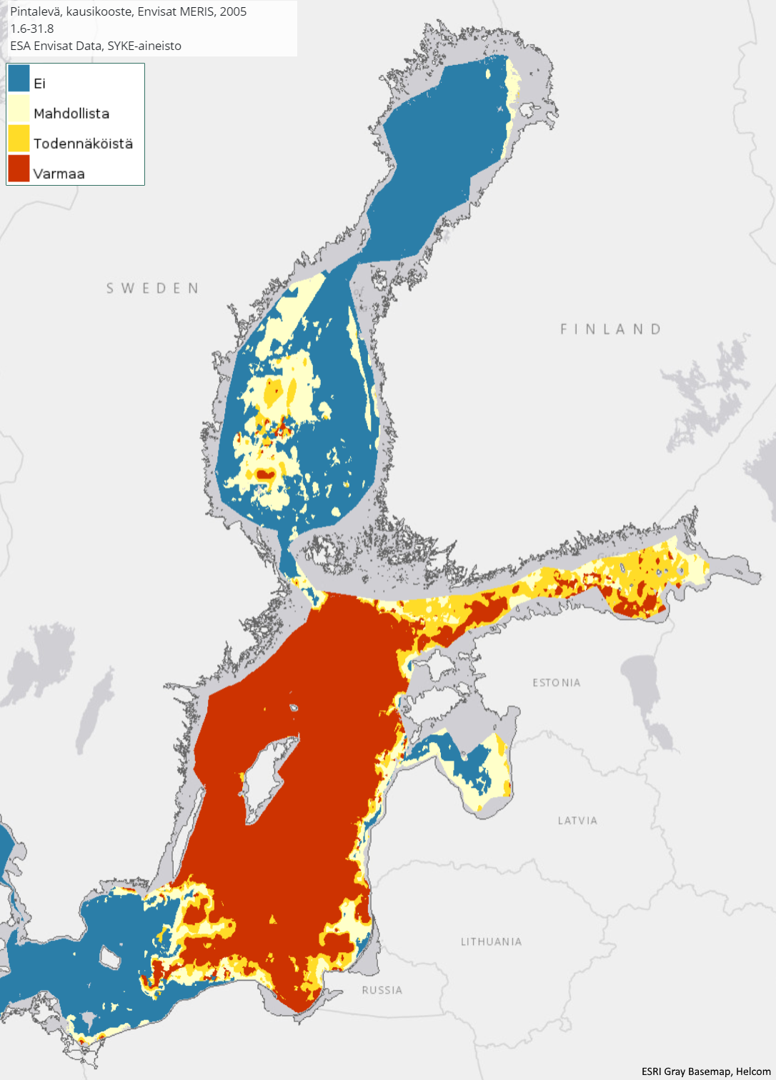 |
| INSPIRE Data Theme | Sea regions |
| GEMET Concepts Keyword | remote sensing |
| GEMET Concepts Keyword | earth observation |
| GEMET Concepts Keyword | satellite image |
| GEMET Concepts Keyword | coastal water |
| GEMET Concepts Keyword | sea water |
| GEMET Concepts Keyword | surface water |
| GEMET Concepts Keyword | water body |
| GEMET Concepts Keyword | Water Framework Directive |
| GEMET Concepts Keyword | water quality |
| GEMET Concepts Keyword | ecological assessment |
| GEMET Concepts Keyword | ecological status |
| GEMET Concepts Keyword | eutrophication |
| GEMET Concepts Keyword | monitoring |
| GEMET Concepts Keyword | algal bloom |
| Resource Classification | Satelliittihavaintotieto |
| Other keywords | Ei-Inspire |
| Other keywords: Thesaurus name | |
| Other keywords | TARKKA |
| Other keywords: Thesaurus name | |
| Other keywords | status assessment |
| Other keywords: Thesaurus name | |
| Other keywords | FEO |
| Other keywords: Thesaurus name | |
| Use constraints and source | Creative Commons Nimeä 4.0 Kansainvälinen [FI] Syke on mainittava lähteenä, jos tuotteita käytetään julkaisuissa tai esityksissä tai saatetaan muulla tavoin yleisön saataviin. Envisat MERIS -aineistoihin perustuva pintalevän kooste: "Syke-aineisto, alkuperäinen data Euroopan avaruusjärjestö (vuosi)" [EN] Syke must be cited as a source if the products are used in publications or performances or otherwise made available to the public. Algae composite based on Envisat MERIS data: "Syke data, original data provided by the European Space Agency (year)" |
| Access Constraints | no limitations |
| Representation Type | grid |
| Resource Language | eng |
| Resource Topic Category | environment |
| Resource Topic Category | oceans |
| Service Type | |
| Begin Date of Temporal Extent | 2003-06-01 |
| End Date of Temporal Extent | 2011-08-31 |
| Lineage Information of Service | [FI] Koosteet on laskettu kesäkauden Envisat MERIS pintalevähavainnoista. [EN] Composites have been calculated from surface algae observations of the Envisat MERIS for the summer season. |