Dataset extent
Ylä-Lapin pääpuulajit
Data and Resources
Additional Info
| Field | Value |
|---|---|
| File Identifier | {CD88DF5F-C9F2-4BEC-AA09-86A09E0DC8CC} |
| Metadata Language | fin |
| Organisation responsible for metadata | Suomen ympäristökeskus |
| Contact information of the organisation responsible for metadata | gistuki@syke.fi |
| The role of the organisation responsible for metadata | pointOfContact |
| Metadata revision date | 2024-04-03 |
| EPSG Code of the Reference System, see https://epsg.io/ | EPSG:3067 |
| Resource Date | 2024-03-12 |
| Resource Date Type | publication |
| Unique Resource identifier | |
| Organisation Responsible for Resource | Suomen ympäristökeskus |
| Contact information of the organisation responsible for Resource | gistuki@syke.fi |
| The role of the organisation responsible for Resource | pointOfContact |
| Thumbnail image | 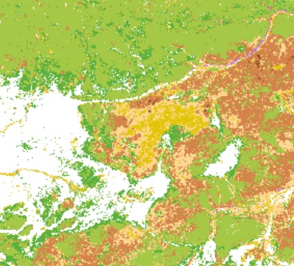 |
| INSPIRE Data Theme | Land cover |
| GEMET Concepts Keyword | coniferous forest |
| GEMET Concepts Keyword | deciduous forest |
| GEMET Concepts Keyword | mixed forest |
| GEMET Concepts Keyword | remote sensing |
| Resource Classification | Paikkatietoaineisto |
| Other keywords | Ei-Inspire |
| Other keywords: Thesaurus name | |
| Other keywords | FEO |
| Other keywords: Thesaurus name | |
| Other keywords | maanpeite |
| Other keywords: Thesaurus name | |
| Other keywords | puulaji |
| Other keywords: Thesaurus name | |
| Other keywords | main tree species |
| Other keywords: Thesaurus name | |
| Other keywords | SYKEn kansallisella rajapinnalla |
| Other keywords: Thesaurus name | |
| Use constraints and source | Creative Commons Nimeä 4.0 Kansainvälinen http://www.syke.fi/fi-FI/Avoin_tieto/Kayttolupa_ja_vastuut Lähde: Syke ja Metsähallitus |
| Access Constraints | no limitations |
| Representation Type | grid |
| Scale (Denominator) | 10000 |
| Resource Language | fin |
| Resource Topic Category | biota |
| Resource Topic Category | environment |
| Service Type | |
| Begin Date of Temporal Extent | None |
| End Date of Temporal Extent | None |
| Lineage Information | Puulajiluokkien välillä on eroja tulkinnan luotettavuudessa ja luotettavimmin erotetuksi saadaan seuraavat luokat: mänty, mänty-seka, kuusi-seka, haapa ja tunturikoivu. Puhtaan kuusen ja koivun tulkinta ei onnistu kovin luotettavasti. |