Dataset extent
Saaristomeren kokonaisfosforiaineistot (Sentinel-2 & Landsat-8/9) 2018-2022 / Total phosphorus of the Archipelago Sea
Data and Resources
-
Tarkka-palvelu / service
-
GetCapabilitiesWMS
-
WMS-esimerkki vuodelta 2020 / WMS example from ...WMS
-
WMS-esimerkki vuodelta 2020 / WMS example from ...WMS
-
Lisätietoa Syken EO-wikissäHTML
-
More information in Syke's EOwikiHTML
-
Sameushavaintojen metatiedot / Metadata for ...
-
Satelliittihavaintojen rajapinnat / EO Web Map ...
Additional Info
| Field | Value |
|---|---|
| File Identifier | {72523E9E-7DAB-438E-A63E-011B9484F3FC} |
| Metadata Language | fin |
| Organisation responsible for metadata | Suomen ympäristökeskus / Finnish Enviroment Institute (Syke) |
| Contact information of the organisation responsible for metadata | eotuki@syke.fi |
| The role of the organisation responsible for metadata | pointOfContact |
| Metadata revision date | 2025-02-24 |
| EPSG Code of the Reference System, see https://epsg.io/ | EPSG:3067 |
| Resource Date | 2021-09-01 |
| Resource Date Type | publication |
| Unique Resource identifier | |
| Organisation Responsible for Resource | Suomen ympäristökeskus / Finnish Enviroment Institute (Syke) |
| Contact information of the organisation responsible for Resource | eotuki@syke.fi |
| The role of the organisation responsible for Resource | pointOfContact |
| Thumbnail image | 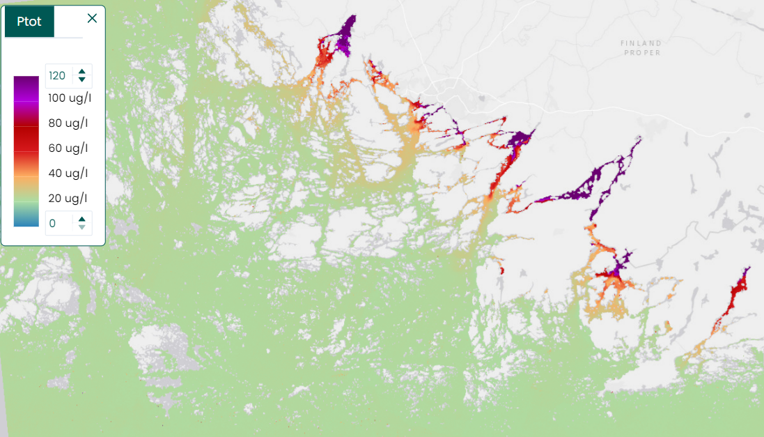 |
| INSPIRE Data Theme | Sea regions |
| GEMET Concepts Keyword | remote sensing |
| GEMET Concepts Keyword | earth observation |
| GEMET Concepts Keyword | satellite image |
| GEMET Concepts Keyword | coastal water |
| GEMET Concepts Keyword | sea water |
| GEMET Concepts Keyword | surface water |
| GEMET Concepts Keyword | water body |
| GEMET Concepts Keyword | Water Framework Directive |
| GEMET Concepts Keyword | water quality |
| GEMET Concepts Keyword | ecological assessment |
| GEMET Concepts Keyword | ecological status |
| GEMET Concepts Keyword | eutrophication |
| GEMET Concepts Keyword | monitoring |
| Resource Classification | Satelliittihavaintotieto |
| Other keywords | Ei-Inspire |
| Other keywords: Thesaurus name | |
| Other keywords | Tarkka |
| Other keywords: Thesaurus name | |
| Other keywords | status assessment |
| Other keywords: Thesaurus name | |
| Other keywords | total phosphorus |
| Other keywords: Thesaurus name | |
| Use constraints and source | Creative Commons Nimeä 4.0 Kansainvälinen [FI] Syke on mainittava lähteenä, jos tuotteita käytetään julkaisuissa tai esityksissä tai saatetaan muulla tavoin yleisön saataviin. Kokonaisfosforiaineistoille: "Syke-aineisto, sisältää muokattua Copernicus ja USGS/NASA Landsat program -dataa (vuosi)". [EN] Syke must be cited as a source if the products are used in publications or performances or otherwise made available to the public. For total phosphorus data: "Syke data, contains modified Copernicus and USGS/NASA Landsat program data (year)". |
| Access Constraints | no limitations |
| Representation Type | grid |
| Resource Language | eng |
| Resource Topic Category | environment |
| Resource Topic Category | oceans |
| Service Type | |
| Begin Date of Temporal Extent | 2018-04-01 |
| End Date of Temporal Extent | 2022-09-28 |
| Lineage Information | [FI] Koosteet on laskettu kevät- ja kesäkauden Sentinel-2 ja Landsat-8 -satelliittien sameushavainnoista. [EN] Composites have been calculated from the turbidity observations of the Sentinel-2 and the Landsat-8 satellites for the spring and the summer season. |