Dataset extent
Itämeren vuosittainen leväkooste (Sentinel-3, Sentinel-2 & Landsat-8/9) 2017– / Yearly algae composites of the Baltic Sea (Sentinel-3, Sentinel-2 & Landsat-8/9) 2017–
Data and Resources
Additional Info
| Field | Value |
|---|---|
| File Identifier | {42D63482-350E-4149-8606-145AFFC0E388} |
| Metadata Language | fin |
| Organisation responsible for metadata | Suomen ympäristökeskus / Finnish Enviroment Institute (Syke) |
| Contact information of the organisation responsible for metadata | eotuki@syke.fi |
| The role of the organisation responsible for metadata | pointOfContact |
| Metadata revision date | 2024-06-17 |
| EPSG Code of the Reference System, see https://epsg.io/ | EPSG:4326 |
| Service Date | 2018-11-05 |
| Service Date Type | publication |
| Unique Resource identifier of Service | |
| Organisation Responsible for Service | Suomen ympäristökeskus / Finnish Enviroment Institute (Syke) |
| Contact information of the organisation responsible for Service | eotuki@syke.fi |
| The role of the organisation responsible for Service | pointOfContact |
| Thumbnail image | 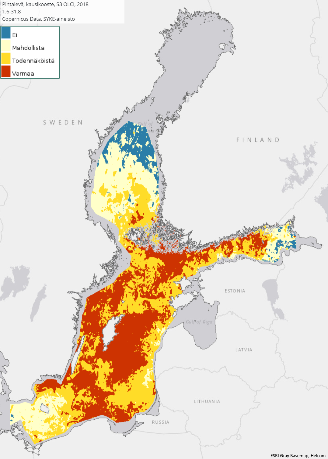 |
| INSPIRE Data Theme | Sea regions |
| GEMET Concepts Keyword | remote sensing |
| GEMET Concepts Keyword | earth observation |
| GEMET Concepts Keyword | satellite image |
| GEMET Concepts Keyword | coastal water |
| GEMET Concepts Keyword | sea water |
| GEMET Concepts Keyword | surface water |
| GEMET Concepts Keyword | water body |
| GEMET Concepts Keyword | Water Framework Directive |
| GEMET Concepts Keyword | water quality |
| GEMET Concepts Keyword | ecological assessment |
| GEMET Concepts Keyword | ecological status |
| GEMET Concepts Keyword | eutrophication |
| GEMET Concepts Keyword | monitoring |
| GEMET Concepts Keyword | algal bloom |
| Resource Classification | Satelliittihavaintotieto |
| Other keywords | Ei-Inspire |
| Other keywords: Thesaurus name | |
| Other keywords | TARKKA |
| Other keywords: Thesaurus name | |
| Other keywords | status assessment |
| Other keywords: Thesaurus name | |
| Other keywords | FEO |
| Other keywords: Thesaurus name | |
| Use constraints and source | Creative Commons Nimeä 4.0 Kansainvälinen [FI] Syke on mainittava lähteenä, jos tuotteita käytetään julkaisuissa tai esityksissä tai saatetaan muulla tavoin yleisön saataviin. Sentinel-3, Sentinel-2 ja Landsat-8/9 -aineistoihin perustuva pintalevä: "Syke-aineisto, sisältää muokattua Copernicus ja USGS/NASA Landsat program -dataa (vuosi)" [EN] Syke must be cited as a source if the products are used in publications or performances or otherwise made available to the public. Algae composite based on Sentinel-3, Sentinel-2 and Landsat-8/9 data: "Syke data, contains modified Copernicus and USGS/NASA Landsat program -data (year)" |
| Access Constraints | no limitations |
| Representation Type | grid |
| Resource Language | eng |
| Resource Topic Category | environment |
| Resource Topic Category | oceans |
| Service Type | |
| Begin Date of Temporal Extent | 2017-01-06 |
| End Date of Temporal Extent | now |
| Lineage Information of Service | [FI] Koosteet on laskettu kesäkauden Sentinel-3 OLCI, Sentinel-2 ja Landsat8/9 pintalevähavainnoista. [EN] Composites have been calculated from surface algae observations of the Sentinel-3 OLCI, Sentinel-2 and Landsat-8/9 for the summer season. |