Dataset extent
Itämeren vuosittainen a-klorofyllin geometrinen keskiarvo (Sentinel-3 OLCI) 2016– / Yearly geometric mean of chlorophyll-a in the Baltic Sea (Sentinel-3 OLCI) 2016–
Data and Resources
-
Tarkka-palvelu / service
-
GetCapabilitiesWMS
-
WMS-esimerkki vuodelta 2018 / WMS example from ...WMS
-
Lisätietoa Syken EOwikissäHTML
-
More information in Syke's EOwikiHTML
-
a-klorofyllihavaintojen metatiedot / Metadata ...
-
Avoin tieto / Satelliittihavaintojen rajapinnat
-
Open information / EO web map services
Additional Info
| Field | Value |
|---|---|
| File Identifier | {259D3770-988C-401E-9223-0D432AA7A47D} |
| Metadata Language | fin |
| Organisation responsible for metadata | Suomen ympäristökeskus / Finnish Environment Institute (Syke) |
| Contact information of the organisation responsible for metadata | eotuki@syke.fi |
| The role of the organisation responsible for metadata | pointOfContact |
| Metadata revision date | 2024-06-18 |
| EPSG Code of the Reference System, see https://epsg.io/ | EPSG:4326 |
| Service Date | 2017-06-26 |
| Service Date Type | publication |
| Unique Resource identifier of Service | |
| Organisation Responsible for Service | Suomen ympäristökeskus / Finnish Environment Institute (Syke) |
| Contact information of the organisation responsible for Service | eotuki@syke.fi |
| The role of the organisation responsible for Service | pointOfContact |
| Thumbnail image | 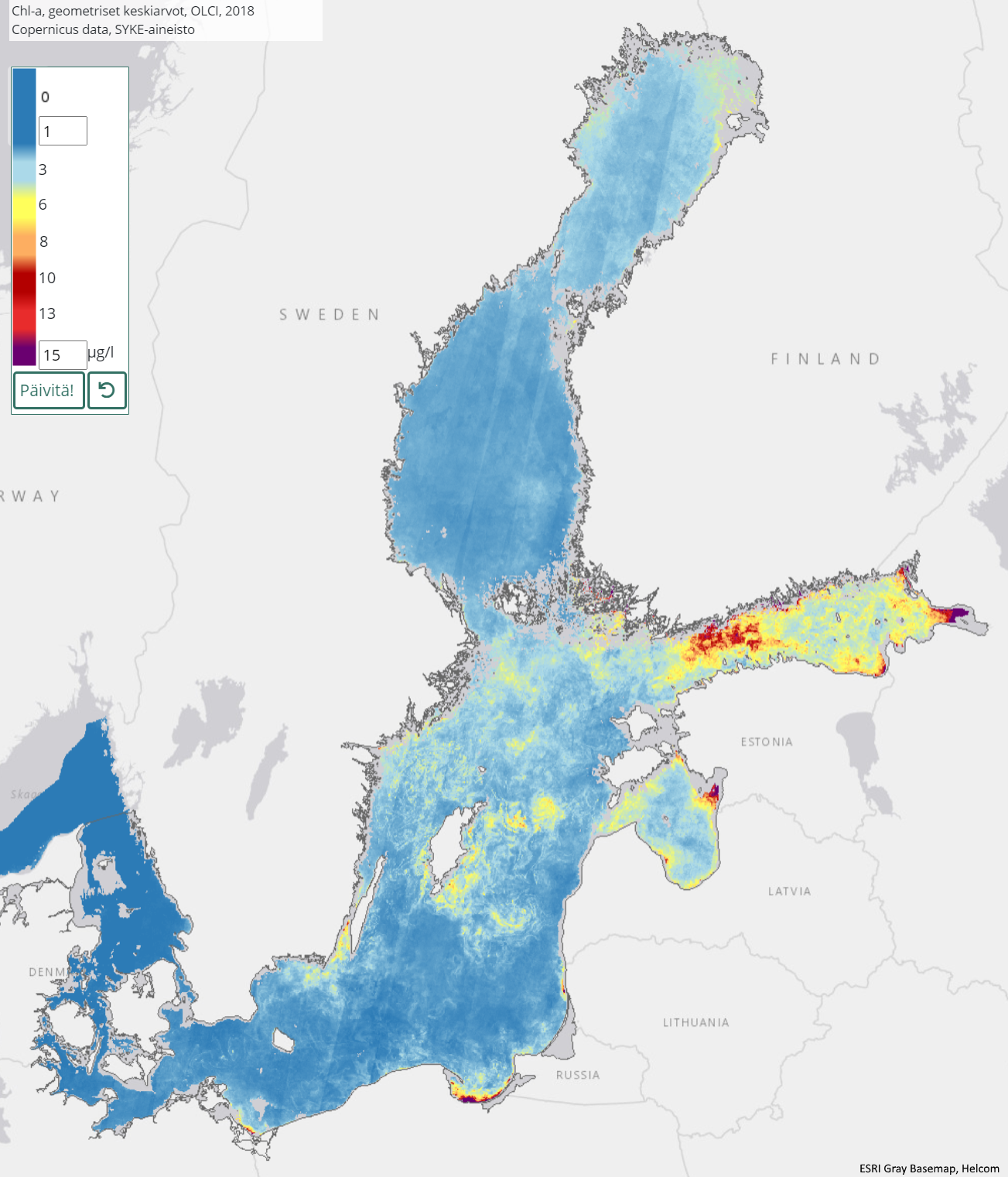 |
| INSPIRE Data Theme | Sea regions |
| GEMET Concepts Keyword | remote sensing |
| GEMET Concepts Keyword | earth observation |
| GEMET Concepts Keyword | satellite image |
| GEMET Concepts Keyword | coastal water |
| GEMET Concepts Keyword | sea water |
| GEMET Concepts Keyword | surface water |
| GEMET Concepts Keyword | water body |
| GEMET Concepts Keyword | Water Framework Directive |
| GEMET Concepts Keyword | water quality |
| GEMET Concepts Keyword | chlorophyll |
| GEMET Concepts Keyword | ecological status |
| GEMET Concepts Keyword | ecological assessment |
| GEMET Concepts Keyword | monitoring |
| GEMET Concepts Keyword | eutrophication |
| Resource Classification | Satelliittihavaintotieto |
| Other keywords | Ei-Inspire |
| Other keywords: Thesaurus name | |
| Other keywords | status assessment |
| Other keywords: Thesaurus name | |
| Other keywords | TARKKA |
| Other keywords: Thesaurus name | |
| Use constraints and source | Creative Commons Nimeä 4.0 Kansainvälinen [FI] Syke on mainittava lähteenä, jos tuotteita käytetään julkaisuissa tai esityksissä tai saatetaan muulla tavoin yleisön saataviin. Sentinel-3-aineistoihin perustuva a-klorofyllin geometrinen keskiarvo: "Syke-aineisto, sisältää muokattua Copernicus-dataa (vuosi)" [EN] Syke must be cited as a source if the products are used in publications or performances or otherwise made available to the public. Geometric mean of chlorophyll-a based on Sentinel-3 data: "Syke data, contains modified Copernicus data (year)" |
| Access Constraints | no limitations |
| Representation Type | grid |
| Resource Language | eng |
| Resource Topic Category | environment |
| Resource Topic Category | oceans |
| Service Type | |
| Begin Date of Temporal Extent | 2016-06-01 |
| End Date of Temporal Extent | now |
| Lineage Information of Service | [FI] Koosteet on laskettu kaikista kesäkauden Sentinel-3-satelliitin OLCI-instrumentin havainnoista. [EN] Composites have been calculated from all observations of the Sentinel-3 satellite's OLCI instrument for the summer season. |