Dataset extent
Itämeren päivittäinen sameusaineisto (Envisat MERIS) 2003–2011 / Daily turbidity of the Baltic Sea (Envisat MERIS) 2003–2011
Data and Resources
Additional Info
| Field | Value |
|---|---|
| File Identifier | {5241F4C8-1F05-4AF0-9A0C-677EBA6BD4A6} |
| Metadata Language | fin |
| Organisation responsible for metadata | Suomen ympäristökeskus / Finnish Environment Institute (Syke) |
| Contact information of the organisation responsible for metadata | eotuki@syke.fi |
| The role of the organisation responsible for metadata | pointOfContact |
| Metadata revision date | 2024-06-17 |
| EPSG Code of the Reference System, see https://epsg.io/ | EPSG:4326 |
| Service Date | 2017-06-26 |
| Service Date Type | revision |
| Unique Resource identifier of Service | |
| Organisation Responsible for Service | Suomen ympäristökeskus / Finnish Environment Institute (Syke) |
| Contact information of the organisation responsible for Service | eotuki@syke.fi |
| The role of the organisation responsible for Service | pointOfContact |
| Thumbnail image | 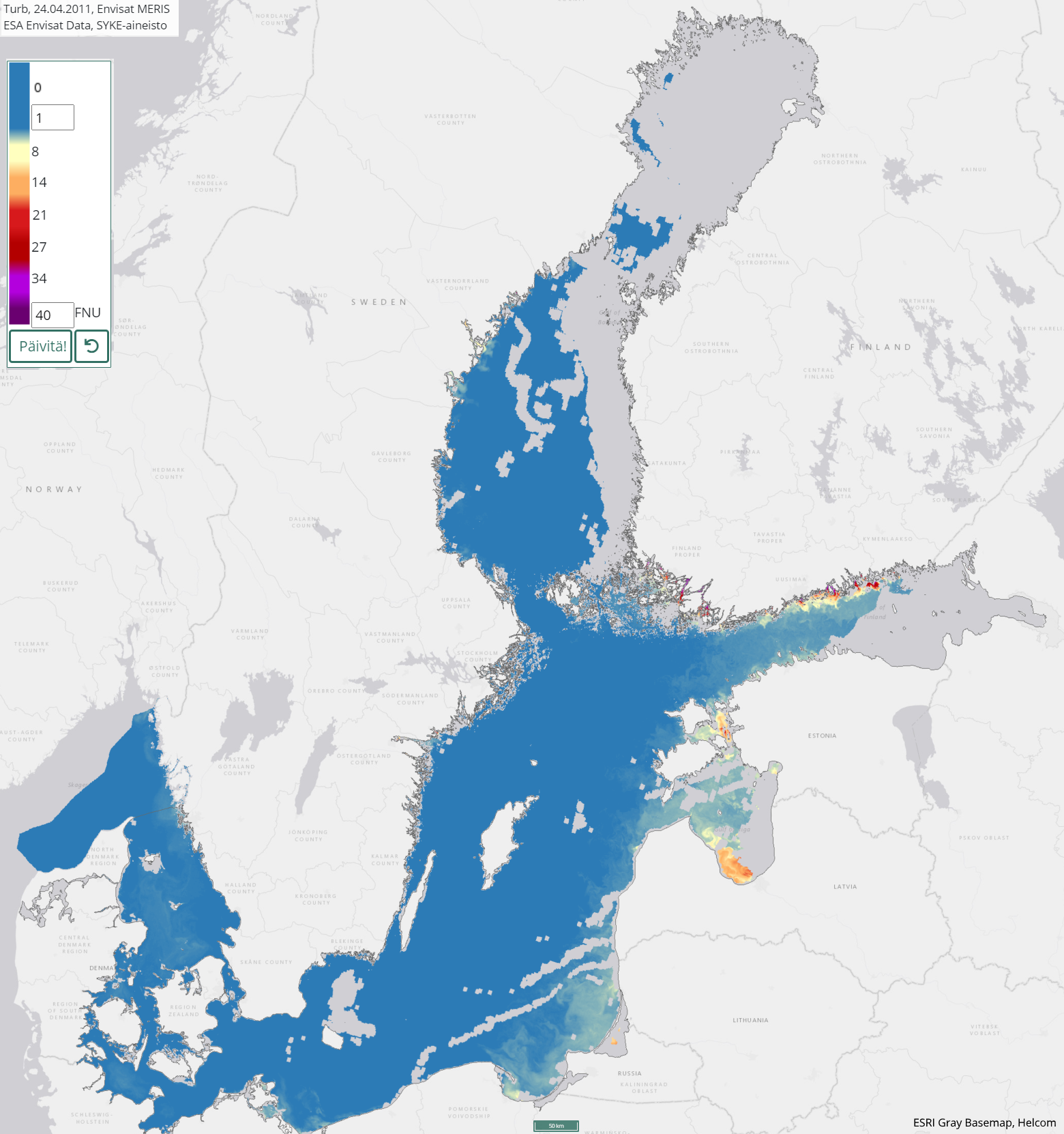 |
| INSPIRE Data Theme | Sea regions |
| GEMET Concepts Keyword | remote sensing |
| GEMET Concepts Keyword | earth observation |
| GEMET Concepts Keyword | satellite image |
| GEMET Concepts Keyword | coastal water |
| GEMET Concepts Keyword | sea water |
| GEMET Concepts Keyword | surface water |
| GEMET Concepts Keyword | water body |
| GEMET Concepts Keyword | Water Framework Directive |
| GEMET Concepts Keyword | water quality |
| GEMET Concepts Keyword | turbidity |
| GEMET Concepts Keyword | ecological assessment |
| GEMET Concepts Keyword | ecological status |
| GEMET Concepts Keyword | monitoring |
| GEMET Concepts Keyword | eutrophication |
| Resource Classification | Satelliittihavaintotieto |
| Other keywords | Ei-Inspire |
| Other keywords: Thesaurus name | |
| Other keywords | status assessment |
| Other keywords: Thesaurus name | |
| Other keywords | TARKKA |
| Other keywords: Thesaurus name | |
| Other keywords | STATUS |
| Other keywords: Thesaurus name | |
| Use constraints and source | [FI] Syke on mainittava lähteenä, jos tuotteita käytetään julkaisuissa tai esityksissä tai saatetaan muulla tavoin yleisön saataviin. Envisat MERIS -aineistoihin perustuva sameus: "Syke-aineisto, alkuperäinen data Euroopan avaruusjärjestö (vuosi)" [EN] Syke must be cited as a source if the products are used in publications or performances or otherwise made available to the public. Turbidity based on Envisat MERIS data: "Syke data, original data provided by the European Space Agency (year) |
| Access Constraints | no limitations |
| Representation Type | grid |
| Resource Language | eng |
| Resource Topic Category | environment |
| Resource Topic Category | oceans |
| Service Type | |
| Begin Date of Temporal Extent | 2003-04-06 |
| End Date of Temporal Extent | 2011-10-31 |
| Lineage Information of Service | [FI] Kaukokartoitusseurantojen tuloksena syntynyt vuosien 2003–2011 havainnoista koostuva päivittäinen sameusaineisto. Prosessointihistoria: Sameus on tulkittu Envisat MERIS-satelliitti-instrumentin 3rd Reprocessing aineistoilta. Alkuperäinen satelliittidata on ladattu Euroopan avaruusjärjestön (ESA) latauspalveluista. Sykessä niistä on laskettu sameustulkinnat käyttäen C2R (Case 2 Regional) -vedenlaatuprosessoria. [EN] Turbidity data from years 2003–2011 for the Baltic Sea. Processing history: The Envisat MERIS 3rd Reprocessing data have been received from ESA service. The dataset has been processed to turbidity values in Syke using the C2R algorithm (Case 2 Regional), which includes atmospheric correction. A quality check have been performed for every daily image. |