Dataset extent
Itämeren ja Suomen järvien päivittäinen sameusaineisto (Landsat-8/9) 2016– / Daily turbidity of the Baltic Sea and Finnish lakes (Landsat-8/9) 2016–
Data and Resources
Additional Info
| Field | Value |
|---|---|
| File Identifier | {7387219C-C9E2-4613-A84D-76FD69F04BD5} |
| Metadata Language | fin |
| Organisation responsible for metadata | Suomen ympäristökeskus / Finnish Environment Institute (Syke) |
| Contact information of the organisation responsible for metadata | eotuki@syke.fi |
| The role of the organisation responsible for metadata | pointOfContact |
| Metadata revision date | 2024-06-17 |
| EPSG Code of the Reference System, see https://epsg.io/ | EPSG:3067 |
| Service Date | 2016-04-14 |
| Service Date Type | publication |
| Unique Resource identifier of Service | |
| Organisation Responsible for Service | Suomen ympäristökeskus / Finnish Environment Institute (Syke) |
| Contact information of the organisation responsible for Service | eotuki@syke.fi |
| The role of the organisation responsible for Service | pointOfContact |
| Thumbnail image | 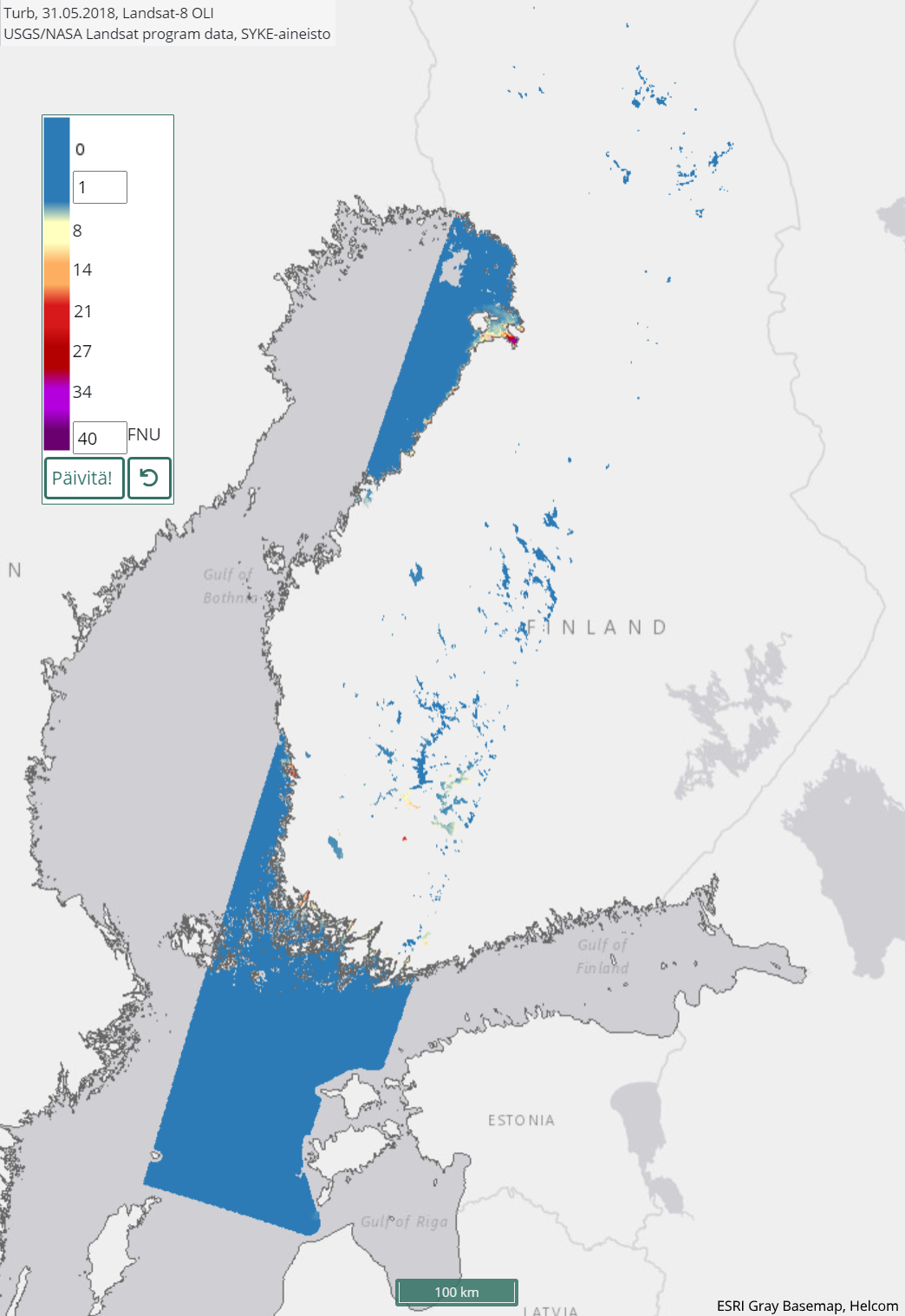 |
| Thumbnail image | 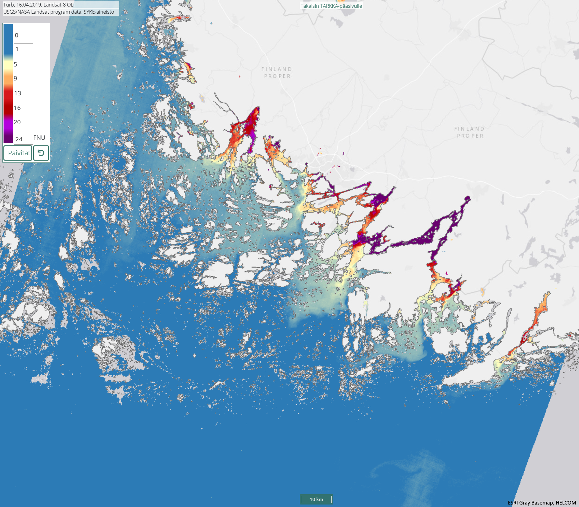 |
| INSPIRE Data Theme | Sea regions |
| GEMET Concepts Keyword | remote sensing |
| GEMET Concepts Keyword | earth observation |
| GEMET Concepts Keyword | satellite image |
| GEMET Concepts Keyword | coastal water |
| GEMET Concepts Keyword | sea water |
| GEMET Concepts Keyword | surface water |
| GEMET Concepts Keyword | water body |
| GEMET Concepts Keyword | Water Framework Directive |
| GEMET Concepts Keyword | water quality |
| GEMET Concepts Keyword | turbidity |
| GEMET Concepts Keyword | freshwater |
| GEMET Concepts Keyword | inland water |
| GEMET Concepts Keyword | ecological assessment |
| GEMET Concepts Keyword | ecological status |
| GEMET Concepts Keyword | eutrophication |
| GEMET Concepts Keyword | monitoring |
| Resource Classification | Satelliittihavaintotieto |
| Other keywords | Ei-Inspire |
| Other keywords: Thesaurus name | |
| Other keywords | TARKKA |
| Other keywords: Thesaurus name | |
| Other keywords | STATUS |
| Other keywords: Thesaurus name | |
| Other keywords | status assessment |
| Other keywords: Thesaurus name | |
| Use constraints and source | Creative Commons Nimeä 4.0 Kansainvälinen [FI] Syke on mainittava lähteenä, jos tuotteita käytetään julkaisuissa tai esityksissä tai saatetaan muulla tavoin yleisön saataviin. Landsat-8/9 aineistoihin perustuva sameus: "Syke-aineisto, USGS/NASA Landsat Program (vuosi)" [EN] Syke must be cited as a source if the products are used in publications or performances or otherwise made available to the public. Turbidity based on Landsat-8/9 data: "Syke data, USGS / NASA Landsat Program (year)" |
| Access Constraints | no limitations |
| Representation Type | grid |
| Resource Language | eng |
| Resource Topic Category | environment |
| Resource Topic Category | inlandWaters |
| Resource Topic Category | oceans |
| Service Type | |
| Begin Date of Temporal Extent | 2016-04-14 |
| End Date of Temporal Extent | now |
| Lineage Information of Service | [FI] Kaukokartoitusseurantojen tuloksena syntynyt sameustulkinta. Vuodesta 2016 eteenpäin koostuva Suomen merialueilta ja järviltä. Prosessointihistoria:Landsat-8 OLI ja Landsat-9 OLI-2 alkuperäinen satelliittidata on ladattu USGS/NASA latauspalveluista. Sykessä niistä on laskettu sameustulkinnat käyttäen C2RCC-mallia (Case-2 Regional CoastColour). [EN] Satellite observations are used to monitor turbidity from years 2016- for the Finnish sea areas and lakes. Processing history: The Landsat-8 OLI and Landsat-9 OLI-2 data have been received from USGS/NASA service. The dataset has been processed to turbidity values in Syke using the C2RCC algorithm (Case-2 Regional CoastColour), which includes atmospheric correction. |