Dataset extent
HELCOM-avomerialueet (2022) / HELCOM offshore sub-basins (2022)
Data and Resources
Additional Info
| Field | Value |
|---|---|
| File Identifier | {E16169CC-94EF-40DF-B40C-12C41DEB0997} |
| Metadata Language | fin |
| Organisation responsible for metadata | Suomen ympäristökeskus / Finnish Environment Institute (Syke) |
| Contact information of the organisation responsible for metadata | eotuki@syke.fi |
| The role of the organisation responsible for metadata | pointOfContact |
| Metadata revision date | 2024-04-08 |
| EPSG Code of the Reference System, see https://epsg.io/ | EPSG:4326 |
| Resource Date | 2022-08-23 |
| Resource Date Type | revision |
| Unique Resource identifier | |
| Organisation Responsible for Resource | HELCOM |
| Contact information of the organisation responsible for Resource | data@helcom.fi |
| The role of the organisation responsible for Resource | owner |
| Thumbnail image | 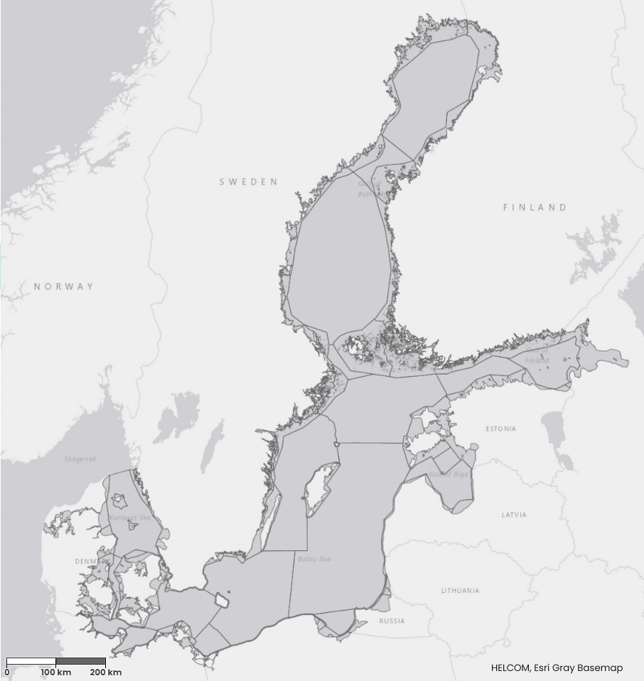 |
| INSPIRE Data Theme | Sea regions |
| GEMET Concepts Keyword | sea |
| GEMET Concepts Keyword | ecological status |
| GEMET Concepts Keyword | ecological assessment |
| GEMET Concepts Keyword | Marine Strategy Framework Directive |
| Resource Classification | Paikkatietoaineisto |
| Other keywords | Ei-Inspire |
| Other keywords: Thesaurus name | |
| Other keywords | status assessment |
| Other keywords: Thesaurus name | |
| Other keywords | Tarkka |
| Other keywords: Thesaurus name | |
| Other keywords | HELCOM |
| Other keywords: Thesaurus name | |
| Use constraints and source | Aineistoa voidaan käyttää vapaasti, kunhan lähde (HELCOM) mainitaan. Aineisto on ladattavissa HELCOMin karttapalvelusta Data can be used freely given that the source (HELCOM) is cited. Data can be downloaded from HELCOM's map service |
| Access Constraints | no limitations |
| Representation Type | vector |
| Resource Language | eng |
| Resource Topic Category | environment |
| Resource Topic Category | oceans |
| Service Type | |
| Begin Date of Temporal Extent | None |
| End Date of Temporal Extent | None |
| Lineage Information | Dataset has been prepared based on polygons of HELCOM open sea basins and merged to WFD water types and water bodies as submitted by HELCOM contracting parties. Data set was modified by request in September 2013 by dividing assessment GER-011 to two areas GER-011 and GER-111". The dataset was corrected in 11 September 2017 regarding Sound-Arkona and Kattegat-Great belt border. This dataset was updated in September 2017 following the update as agreed in https://portal.helcom.fi/meetings/STATE - CONSERVATION 6-2017-412/MeetingDocuments/Outcome of State and Conservation 6-2017.pdf. Islands under 1 ha have been removed from the dataset and polygon shape have been simplified with bend simplify tool with 100m maximum allowable offset in September 2017. The dataset was updated again in 2022 with changes collected for HELCOM assessment units to be applied in HOLAS III, presented on State and Conservation 15-2021, document 3J-94 Furthermore, the dataset was updated in 2022 to also incorporate the splitting of Bornholm Basin (SEA-007) into two assessment units with the separation of the Pomeranian Bay and the redefinition of the boundaries for the Gulf of Finland (SEA-013) applied only for the eutrophication assessment, as presented in State and Conservation 14-2021 outcome. In august 2022 the dataset was updated to incorporate changes on the Danish coast, resulting in changes in the areas of Kiel Bay and the Great Belt. |