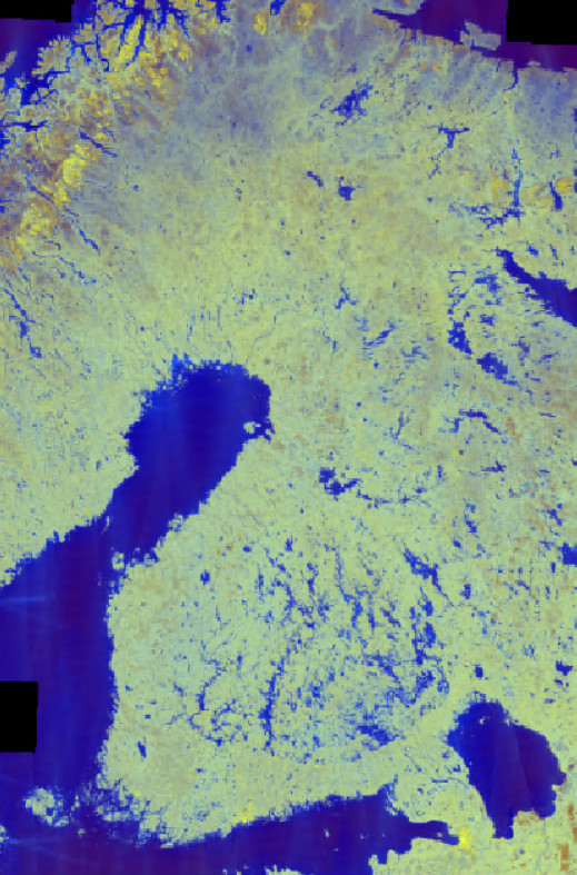
Sentinel-1 Global Backscatter Model-satellite image mosaic (S1GBM,
https://sentinels.copernicus.eu/web/sentinel/missions/sentinel-1/sentinel-1-global-backscatter-model) was produced by the Remote Sensing Group of the TU Wien Department of Geodesy and Geoinformation (https://mrs.geo.tuwien.ac.at/), within project by the European Space Agency (ESA). It is based on Sentinel-1A and -1B synthetic aperture radar images
(https://sentinels.copernicus.eu/web/sentinel/missions/sentinel-1) acquired between 1.1.2016-31.12.2017. Imaging mode has been Interferometric Wide-swath (IW) and baseline processing of images GRDH (Ground-Range Detected High Resolution). The resulting mosaic provides the temporal mean of VV- and VH-polarized C-band backscatter of the Earth's land surface with 10 meter pixel size, normalized to incidence angle of 38°.
The original data set is hosted by TU Wien (https://www.tuwien.at/en/) and can be accessed via the TU Data repository website (https://doi.org/10.48436/n2d1v-gqb91).
The processing of data at Syke consists of
coordinate transformation to Finnish coordinate system (TM35Fin, EPSG 3067)
computation of polarization ratio VV/VH and scaling that to 8-bit scale by multiplying the ratio with coefficient 100
* VV- ja VH-polarized mosaics and their polarization ratio has been saved as three-band raster (bands: 1. VV-backscatter, 2. VH-backscatter, 3. polarization ratio VV/VH multiplied with coefficient 100) as 8-bit Cloud-optimized-GeoTiff.
Mosaic is published in FEO-project. It is available e.g. from the archive of Finnish Satellite Data Centre: https://pta.data.lit.fmi.fi/sen1/s1gbm/s1gbm_20160101_20171231_vv_vh_ratio.tif
Sentinel-1 Global Backscatter Model-kuvamosaiikki
Sentinel-1 Global Backscatter Model-satelliittikuvamosaiikin (S1GBM, https://sentinels.copernicus.eu/web/sentinel/missions/sentinel-1/sentinel-1-global-backscatter-model) on tehnyt Wienin yliopiston Kaukokartoitusryhmä (https://mrs.geo.tuwien.ac.at/) Euroopan avaruusjärjestön rahoituksella. S1GBM-mosaiikki perustuu Sentinel-1A ja -1B kaukokartoitussatelliittien (https://sentinels.copernicus.eu/web/sentinel/missions/sentinel-1) tutkainstrumenttien aikavälillä 1.1.2016-31.12.2017 ottamiin kuviin. Kuvien kuvausmoodina on ollut Interferometric Wide-swath (IW) ja käytettyjen kuvien prosessointitasona GRDH (Ground-Range Detected High Resolution). Tuloksena on Maapallon maa-alueiden VV- ja VH-polarisaatioiden takaisinsironnan ajallinen keskiarvo, 10 metrin pikselikkoossa ja normalisoituna 38 asteen tulokulmaan.
Alkuperäinen S1GBM-mosaiikki on saatavilla Wienin yliopiston (https://www.tuwien.at/en/) TU Data repository-arkiston kautta (https://doi.org/10.48436/n2d1v-gqb91).
S1GBM-mosaiikki on ladattu Sykeen ja sille on tehty seuraavat toimenpiteet:
koordinaatistomuunnos Suomen koordinaatistojärjestelmään (TM35Fin, EPSG 3067),
polarisaatiosuhteen VV/VH laskenta (tulos on kerrottu kertoimella 100), ja
* VV- ja VH-polarisaatioiden mosaiikit ja näiden suhde on tallennettu 3-kanavaiseksi rasterikuvaksi (kanavat: 1. VV-takaisinsironta, 2. VH-takaisinsironta, 3. polarisaatiosuhde VV/VH kerrottuna kertoimella 100) käyttäen Cloud-optimized-GeoTiff-formaattia ja 8-bittistä lukualuetta (0-255).
Mosaiikki julkaistaan FEO-hankkeessa. se on saatavilla mm. Kansallisen satelliittidatakeskuksen arkistosta: https://pta.data.lit.fmi.fi/sen1/s1gbm/s1gbm_20160101_20171231_vv_vh_ratio.tif
Rights: Original data are reserved with TU Wien and ESA. Open use is granted under the CC BY 4.0 license.
References:
Bauer-Marschallinger, B., Cao, S., Navacchi, C., Freeman, V., Reuß, F., Geudtner, D., Rommen, B., Vega, F. C., Snoeij, P., Attema, E., Reimer, C., & Wagner, W. (2021). The Sentinel-1 Global Backscatter Model (S1GBM) - Mapping Earth's Land Surface with C-Band Microwaves (1.0) [Data set]. TU Wien. https://doi.org/10.48436/n2d1v-gqb91
Bauer-Marschallinger, B., Cao, S., Navacchi, C. et al. The normalised Sentinel-1 Global Backscatter Model, mapping Earth’s land surface with C-band microwaves. Sci Data 8, 277 (2021). https://doi.org/10.1038/s41597-021-01059-7