Dataset extent
Corine maanpeite 2006
Data and Resources
Additional Info
| Field | Value |
|---|---|
| File Identifier | {703D5B2B-4CCC-49A7-B9E9-92B2E1290CD3} |
| Metadata Language | fin |
| Organisation responsible for metadata | Suomen ympäristökeskus |
| Contact information of the organisation responsible for metadata | gistuki@syke.fi |
| The role of the organisation responsible for metadata | pointOfContact |
| Metadata revision date | 2024-02-15 |
| EPSG Code of the Reference System, see https://epsg.io/ | EPSG:3067 |
| EPSG Code of the Reference System, see https://epsg.io/ | EPSG:3035 |
| Resource Date | 2004-01-17 |
| Resource Date Type | publication |
| Unique Resource identifier | http://paikkatiedot.fi/so/1000057/lc/LandCoverUnit |
| Organisation Responsible for Resource | Suomen ympäristökeskus |
| Contact information of the organisation responsible for Resource | gistuki@syke.fi |
| The role of the organisation responsible for Resource | owner |
| Thumbnail image | 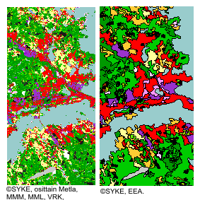 |
| INSPIRE Data Theme | Land cover |
| GEMET Concepts Keyword | land use |
| GEMET Concepts Keyword | environmental monitoring |
| Spatial Scope of INSPIRE data | National |
| Resource Classification | Paikkatietoaineisto |
| Other keywords | Maanpeite |
| Other keywords: Thesaurus name | |
| Other keywords | Maankäyttö |
| Other keywords: Thesaurus name | |
| Other keywords | INSPIRE-tietotuote |
| Other keywords: Thesaurus name | |
| Other keywords | FEO |
| Other keywords: Thesaurus name | |
| Use constraints and source | Creative Commons Nimeä 4.0 Kansainvälinen http://www.syke.fi/fi-FI/Avoin_tieto/Kayttolupa_ja_vastuut Lupatekstit Lähde: Syke, EEA (vektoriaineistolle ) Lähde: Syke (osittain METLA,MMM,MML,DVV) (rasteriaineistolle) |
| Access Constraints | no limitations |
| Representation Type | vector |
| Scale (Denominator) | 100000 |
| Resource Language | fin |
| Resource Topic Category | environment |
| Service Type | |
| Begin Date of Temporal Extent | 2006-01-01 |
| End Date of Temporal Extent | unknown |
| Lineage Information | CLC2006-aineiston tuottamisessa käytetty IMAGE2006 satelliittikuvamosaiikki koostuu IRS P6 - ja SPOT 4/5 satelliittikuvista. Kuvat on vastaanotettu vuosina 2005 ja 2006. Satelliittikuvilta estimoitiin puuston pituus ja puuston kokonaislatvuspeitteisyys ja lehtipuuston latvuspeitteisyys. Puustoa kuvaavat muuttujat tuotettiin Metsäntutkimuslaitoksessa käyttäen hyväksi valtakunnan metsien inventoinnin maastoahavaintoaineistoa ja satelliittikuvien tulkintamenetelmää (k-nn). Prosessin osana myös metsäaineistojen laatu on varmistettu. Automaattista satelliittikuvatulkintaa käytettiin myös Ylä-Lapissa puurajan yläpuolisilla alueilla CLC-maanpeiteluokan määrittämisessä. Tulkinnassa hyödynnettiin lisäksi mm. Metsähallituksen biotooppiaineistoa, digitaalista korkeusmallia ja maaperää kuvaavia teemoja Maastotietokannasta. Lisäksi muutamia luokkia tulkittiin satelliittikuvilta manuaalisesti digitoimalla, kuten golfkentät. CLC2006-luokkien muodostamiseen on käytetty useita eri paikkatietoaineistoja, tärkeimpinä Maastotietokanta, Digiroad, Väestötietojärjestelmä (Rakennus- ja huoneistorekisteri), SLICES ja CLC2000. Paikkatietoaineistoista saatu maankäyttö ja maaperätieto yhdistettiin satelliittikuvilta tulkittuihin maanpeitetietoihin. Lopputuloksena saatiin rasterimuotoinen paikkatietoaineisto 25 metrin pikselikoolla. Satellite image interpretation IMAGE2006 satellite image mosaic, which the CLC2006 is based on, consists 47 IRS P6 images and 36 SPOT 4/5 images from the years 2005 and 2006. The satellite images were geometrically corrected by Metria Sweden. Atmospheric correction and in Northern Finland also topographic correction was executed in Syke as well as manual cloud masking. After these corrections mosaicing of individual satellite images were carried out. From the satellite images it was possible to estimate tree heights and both overall crown coverage and crown coverage of broad-leaved trees. These were produced in Finnish Forest Research Institute and the National Forest Inventory Data was used. During this process, the quality of the data was also verified. Automatic satellite imagery interpretation was also used to determine the land cover classes above the tree line in Northern Lapland. Some classes were also manually interpreted from the satellite images (eg. golfcourses). Data integration with GIS data Many geographic data sources were used in CLC2006 creation, most significantly Topographic Database of Finland, Digiroad (digital road database of Finland), SLICES land use database and CLC2000 database. Soil information and land use data from the geographic sources were integrated with data interpreted from satellite images. Detailed class definitions and production methods can be found in annex documents. The resulting national raster database (25m x 25 m) was generalized according to the CORINE 2006 project class definitions and land cover change rules. |